The world is facing a huge issue with water, as it is a super finite resource with only an estimated 1% of it being fresh and drinkable. In the past year it’s been ranked as the highest urgency crisis for the next decade by the World Wildlife Foundation and the World Economic Forum. Statistics show that without a change in practices, the demand for water will be 40% greater than supply by 2030. That’s less than 20 years away and will soon become a serious issue that will effect the daily lives of all beings if we don’t start using water wisely.
It’s not that we’re getting less rain than we always have, it’s that the fresh water is becoming either toxic or inacessable, and rapid population growth means tapping more rivers and springs more than they can handle. One major source of loss is the lack of water retention in poor soils causing us to irrigate more and lose more to the groundwater table. Another is the use of water for sewage systems, and the fact that in urban environments, water isn’t absorbed into the soil at all, it just absorbs pollution in the streets and gets drained and emptied out elsewhere. Many of these pollutants in the water are permanent, and we don’t yet know if we’ll ever come up with a way to remove them to make the water fresh again. Wetland environments are also frequently destroyed for property development, and these environments are crucial to filtering our water.
In these daunting times, designing our lives to use water in the most efficient and regenerative matter is one of the most crucial things we can do. When water arrives on our property, we must ask ourselves where it enters and exits, and how we can leave it cleaner when it runs off than it was when it arrived. The permaculture mantra is ‘slow it, sink it, spread it!’ Conventional house design often just directs rainwater off of the property and into the sewers rather than using it at all. In order to make the best use of this resource, we can use some techniques to use it for our advantage.
One of my favorite examples is the use of swales and terraces. Swales are small ditches dug next to plant beds or trees to create a basin for infiltration, which means when water runs into them, it stops and is slowly drained into the soil rather than sliding off and causing erosion. It’s often implemented on slopes to allow for more even irrigation. Terraces are just like staircases made on hills that are used for the same reasons.

Swales depiction
Another popular method of wise water usage is called keyline ripping. A plow comes through with fork like prongs that dig lines along the contours of the land, loosening up the soil and providing slits to let water soak in. This can be done a few times to create a bunch of little pockets of water storage in a landscape.

Keyline Ripping
Fascines, piles of brush lined against ditches and swales, or other areas where water puddles up can be used to add organic matter and provide mini shelter belts from erosion by holding on to water and letting it drip slowly instead of rushing by.
Raised beds are also a pretty key factor for water retention as porous, absorbent mounds of rich soil can hold on to the water and provide it to plants. To really improve freshwater usage, it’s just important to fill the soil with as much biomass as possible, keep it covered in plants and build up the organic matter layer with compost and mulches.
Then there are plenty of ways to make better use of our water. Driveways and sidewalks can be made with permeable surfaces instead of entirely flat concrete. Gardens can be made in areas where storm water runoff collects from roads, and on top of rooftops!

Examples of permeable surfaces

Garden absorbing road runoff
It’s also best to catch water where it really counts. The inflection point is the spot on a slope in which the angle switches from convex to concave, and immediately following it is the keyline point, where the force of water movement changes from erosive to depository. Mapping the topography of a slope allows us to find these points and create a structure like a keyline dam, which simply collects water there and then channels outwards to the rest of a field for even distribution.
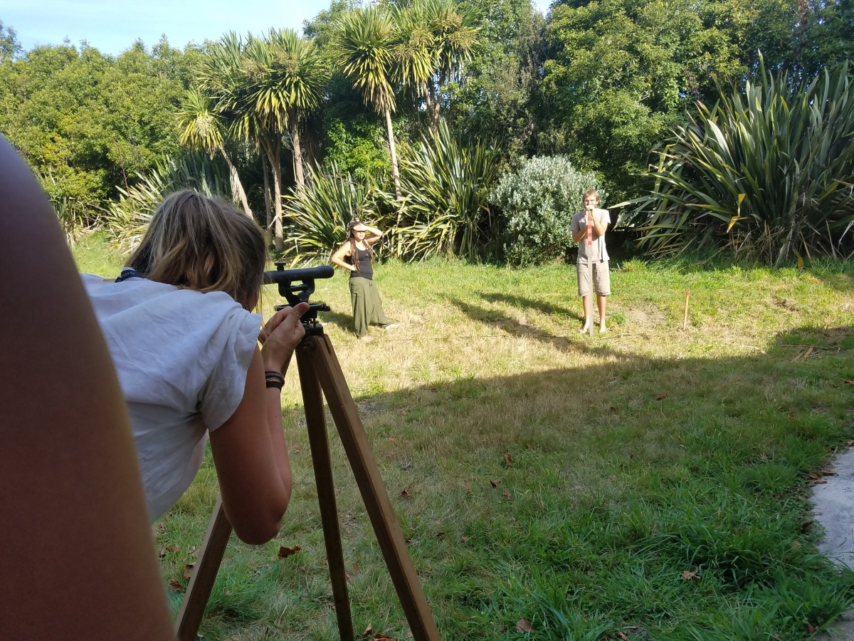
I got the chance to practice a few different methods of mapping a slope!
A dumpy level, which is calibrated at one point of a contour and then spun around to identify other spots at the same contour which can be staked and mapped

A simple way to calculate contours. A bucket of water is placed on a flat surface (such as this crate). Then a clear tube is inserted into the bucket on one end and taped to a measuring stick on the other. Then someone inhales on the measuring stick side to fill the tube with water, and the level that it comes to is marked. The stick can then be moved from side to side across the slope, and at the same elevation the water level will be the same.

A clinometer can be used with just the eye and two people. One person walks around on a slope staking points at the same angle, which can be seen by the person at the bottom through the box.

The A-frame can be used by simply moving it across from point to point and calibrating the weight at the center to see even elevations
We also clay-crafted an island and then mapped the topography of it by etching it in with matchsticks. We even built a miniature keyline dam with dendritic irrigation channels expanding from it, and poured water on top to watch it all working.

Crafting together

Topography exercise

Initiating keyline dam construction