The Evergreen State College

Landscapes of Change: Dry Falls

Writing & Mapping the Future

Main menu

Skip to primary content
Skip to secondary content
  • Landscapes of Change
  • Dry Falls
    • Maps
    • Field Notes
    • Collage Essays
    • Galleries
  • Dry Falls Map

Tag Archives: La Mesa Map

La Mesa Journey

Posted on October 20, 2012 by Brylie Oxley
Reply

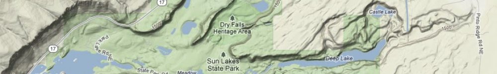
On day two, the Carrot Spoons made the journey to La Mesa. On the way back, we explored a huge channel, which turned out not to be a shortcut. It was great anyway! Their track is meandering, and appears to … Continue reading →

Posted in Carrot Spoons, Maps | Tagged La Mesa, La Mesa Map, Tracks | Leave a reply

Interdisciplinary Narrative

We have attempted to understand and represent diverse landscapes as "places" - intersections of ecology, culture, and personal meaning.

Select by Project Team or by Post-type

  • Collage Essays (27)
  • Field Notes (27)
  • Galleries (27)
  • Maps (27)
  • Teams (108)
    • Carrot Spoons (12)
    • Daytrippers (12)
    • G-Rated (12)
    • Group4 (12)
    • J.E.J (12)
    • Mr J (12)
    • Olympians (12)
    • The Dry Fallions (12)
    • Timon (12)
  • Uncategorized (4)

Locations

  • Alex
  • Basin
  • broken
  • CarrotSpoon
  • Cliff
  • clouds
  • Collage Essay
  • Daytrippers
  • Deep Lake
  • Deep Lake Pothole and Cave
  • Delaney Spring
  • Dry Falls Lake
  • Dry Gully
  • Emma
  • field notes
  • G-rated
  • Galleries
  • Gallery
  • Giant's Footprint
  • Green Lake
  • Hanging Canyon
  • J.E.J
  • La Mesa
  • Map
  • maps
  • Mossbottom Pothole
  • Mr J
  • of
  • olympia
  • Olympians
  • Patrick
  • Pothole
  • Potluck
  • Red Alkali Lake
  • Saddle
  • Shore
  • Southern Escarpment
  • South Mesa
  • the cliff
  • the dry fallions
  • The Longitudinal Groove
  • Umatilla Rock
  • Umatilla Saddle
  • weeping
  • Wes

Links

  • Landscapes of Change

Meta

  • Log in
  • Entries RSS
  • Comments RSS
  • WordPress.org

The Evergreen State College Olympia, Washington
| Log in