A Glimpse into the Future Part II: Capitol Lake
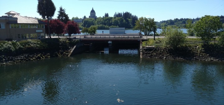
The Dam
Currently, there are some problems with the lake and the dam. One of the biggest issues is that the Deschutes is filling the lake with sediment, which if left unchecked will turn the lake into a marsh. Some other big issues are invasive species in the lake and water quality issues. A few options for the future of the dam are:
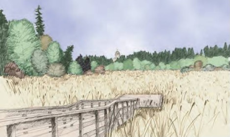
Artist’s concept of the Status Quo option (image found on page 7 of the Capitol Lake Alternatives Analysis Final Report by Herra Environmental Consultants (link to document earlier in post))
Status Quo: Keep the lake and its management the same for the future. Nothing big would change immediately, but over the next few decades the lake would fill with sediment and become a marsh.
- The same amount of sediment would be flowing into Budd Inlet and to the Port and marinas.
- Fish habitat would degrade over time and the dam would still be a bottleneck for migrating salmon, increasing the danger of predation.
- Invasive plants, amphibians, and mammals would be supported, though nonnative fish species would suffer the same as native ones as the lake filled with sediment.
- The dam will need repairs over time.
- Downtown will be at no greater risk of flooding from this method, though the protective berm will need to be raised eventually to protect downtown from flooding as sea levels rise.
- Current recreation opportunities would stay the same in the short term, though in the long term boating would be impossible on the lake and expanding marshland would encroach on walking trails.
- The reflecting pool would eventually disappear.
- Native American values here would continue to be unsupported and the historical connection people feel to the place would diminish as the lake filled in and became a marsh.
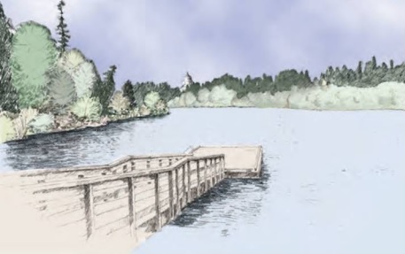
Artist’s concept of the Managed Lake option (image found on page 8 of the Capitol Lake Alternatives Analysis Final Report by Herra Environmental Consultants (link to document earlier in post))
Managed Lake: There would be one big initial dredge to get rid of built up sediment and then many smaller maintenance dredges on into the future. No change to the lake’s uses over time
- Big initial dredge with smaller dredges every ten years. The Port and marinas would have the same amount or less of dredging to do in the future.
- Fish would do better as the dredging of the lake would expand their habitat, though migrating fish would still experience the bottleneck at the dam.
- Invasive species would flourish.
- The dam will need repairs over time
- Downtown will be at no greater risk of flooding from this method, though the protective berm will need to be raised eventually to protect downtown from flooding as sea levels rise.
- Recreation opportunities in and around the lake would stay the same but would occasionally be interrupted or unavailable due to dredging.
- The reflecting pool would be retained.
- Native American values of this place would continue to be unsupported. This option may improve community identity in Olympia as the lake will not be diminished.
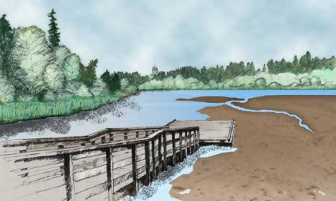
Artist’s concept of the Estuary option (image found on page 9 of the Capitol Lake Alternatives Analysis Final Report by Herra Environmental Consultants (link to document earlier in post))
Estuary: The dam would be taken down and the Fifth Avenue bridge rebuilt over the estuary. There would be a slight shift of how Deschutes Parkway and Fifth Avenue meet that changes roads and walking paths slightly.
- Big dredge of the lake before the dam is removed and then a roughly 25 year period where there is no dredging and the estuary can reach equilibrium. Dredging every five years after this period. The Port and marinas would need to dredge more.
- Freshwater fish would die out but marine fish would come in and migrating fish would have a greater chance of surviving migration with the removal of the dam.
- Many of the nonnative species currently in the lake would be greatly reduced or eliminated due to the reintroduction of salt water, but there would be the possibility of invasive marine species in the area.
- Most sewer lines, as well as some roads and bridges, that currently run around or across the lake would need to be replaced to protect against damage from salt water and higher velocity of water.
- Downtown will be at no greater risk of flooding from this method, though the protective berm will need to be raised sooner that with the previous alternatives to protect downtown from flooding as sea levels rise.
- Some recreation activities such as the Dragon Boat Festival would need to be scheduled for high tide or be moved elsewhere. However, most recreation would for the most part be the same. Boating activities would no longer be blocked by the dam but would be limited in the estuary on low tide.
- The reflecting pool would not be retained.
- Native American values in this area would be restored. Community values in the area would be changed but not necessarily diminished.
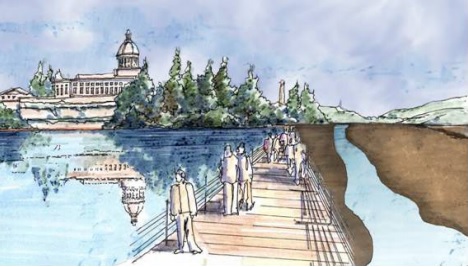
Artist’s concept of the Dual-Basin Estuary option (image found on page 10 of the Capitol Lake Alternatives Analysis Final Report by Herra Environmental Consultants (link to document earlier in post))
Dual-Basin Estuary: Remove the dam and do the same bridge building and road shifting that is required for the estuary option but also put up a 1,900 foot long barrier to hold water and create a saltwater reflecting pool on the east side of the estuary.
- Roughly the same dredging needs as the estuary option.
- There would be about the same impact on plants and animals as the estuary option, though it is important to note that the water quality of the saltwater reflection pool could be less than the estuary.
- All the impacts to infrastructure of the estuary would apply here plus there would need to be the building and maintenance of the reflecting pool barrier.
- Downtown will be at no greater risk of flooding from this method, though the protective berm will need to be raised sooner that with the alternatives where the dam is kept to protect downtown from flooding as sea levels rise.
- Some recreation activities such as the Dragon Boat Festival would need to be scheduled for high tide or be moved elsewhere. However, most recreation would for the most part be the same. Boating activities would no longer be blocked by the dam but would be limited in the estuary on low tide. There would also be a new walkway for people on top of the reflecting pool barrier.
- The reflecting pool would be retained.
- There would be a similar restoration of support for Native American values of the area. There would also be a similar shift in community values but the community would still have the reflecting pool.