VISUALIZING CLIMATE CHANGE

  • Home
  • Olympia
    • Map of Olympia Field Study Sites
    • Past
    • Present
    • Future
    • Best Of
  • Olympic Peninsula
  • Rainier

VISUALIZING CLIMATE CHANGE

How to get others to see

  • Home
  • Olympia
    • Map of Olympia Field Study Sites
    • Past
    • Present
    • Future
    • Best Of
  • Olympic Peninsula
  • Rainier
  • 0

IMG_1447

by skieri23 · May 2, 2016

  • Previous story IMG_1447

You may also like...

  • 2

    The Path over the Dam and around the Lake

    May 24, 2016

     by skieri23 · Published May 24, 2016 · Last modified June 2, 2016

  • 1

    Capitol Dome’s Reflection

    May 2, 2016

     by skieri23 · Published May 2, 2016 · Last modified May 24, 2016

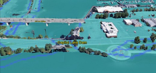
  • 1

    The Capitol Lake Dam Future

    May 22, 2016

     by skieri23 · Published May 22, 2016 · Last modified June 2, 2016

Leave a Reply Cancel reply

Your email address will not be published. Required fields are marked *

Tags

adrenaline rush algae blooms Arc of Statehood Capitol Building Capitol Lake Capitol Lake Building Capitol Lake Dam County Markers Deschutes Parkway Deschutes River Ducks fecal Coliform bacteria Fish Ladder Grates Great Blue Heron Heritage Park Joggers love Mallards Merganser New Zealand Mudsnail North Basin Shoreline trail Parents Path Percival Cove Salmon Sea-Level Rise Sidewalk art Sidewalk Loop Trail Strollers Tumwater Falls Windy

Posts by Category

  • Best Of (5)
  • Olympia Future (2)
  • Olympia Past (2)
  • Olympia Present (13)

Olympia Links

  • Map of Olympia Field Sites
  • Olympia Historical Society & Bigelow House Museum
  • Sanborn Overlays
  • WA Secretary of State Map Archive

VCC Blogs

  • VCC Template

Meta

  • Log in
  • VCC WordPress Workshop

Categories

  • Best Of
  • Olympia Future
  • Olympia Past
  • Olympia Present

VISUALIZING CLIMATE CHANGE © 2025. All Rights Reserved.

Powered by  - Designed with the Hueman theme