SITE ANALYSIS
- Site analysis is the process of studying the contextual forces that influence how we might situate a building, layout and orient its spaces, shape and articulate its enclosure and establish its relationships to the landscape. Any survey begins with the gathering of the physical site data. Below are guidelines that are recommended to follow from the “”Building Construction Illustrated 4th edition” book:
- Draw the area and shape of the site as defined by its legal boundaries.
- Indicate required setbacks, existing easements, and rights-of-ways.
- Estimate the area and volume required for the building program, site amenities, and future expansion, if desired.
- Analyze the ground slopes and subsoil conditions to locate the areas suitable for construction and outdoor actives
- Identify steep and moderate slopes that may be unsuitable for development
- Locate soil areas suitable for use as a drainage field, if applicable.
- Map existing drainage patterns. (LEED SS Credit 6: Storm water design)
- Determine the elevation of the water table
- Identify areas subject to excessive runoff of surface water, flooding, or erosion
- Locate existing trees and native plant materials that should be preserved
- Chart existing water features, such as wetlands, streams, watersheds, flood plains, or shorelines that should be protected (LEED SS Credit 5: Site Development, Protect or Restore Habitat)
- Map climatic conditions: the path of the sun, the direction of prevailing winds, and the expected amount of rainfall
- Consider the impact of landforms and adjacent structures on solar access, prevailing winds, and the potential for glare
- Evaluate solar radiation as a potential energy source
- Determine possible points of access from public roadways and public transit stops. (LEED SS Credit 4: Alternative Transportation)
- Study possible circulation paths for pedestrians and vehicles from these access points to building entrances
- Ascertain the availability of utilities: water mains, sanitary and storm sewers, gas lines, electrical power lines, telephone and cable lines, and fire hydrants
- Determine access to other municipal services, such as police and fire protection
- Identify the scope of desirable views as well as objectionable views
- Cite potential sources of congestion and noise
- Evaluate the compatibility of adjacent and proposal land uses
- Map cultural and historical resources that should be preserved
- Consider how the existing scale and character of the neighborhood or area might affect the building design
- Map the proximity to public, commercial, medical, and recreational facilities. (LEED SS Credit 2: Development Density & Community Connectivity)
TOPOGRPAHY
- Topography refers to understanding the configuration and surface features of a plot of land. Below are ways of understanding topography:
- Contour lines are imaginary lines joining points of equal elevation above a datum or bench mark. The trajectory of each contour line indicates the shape of the land formation at that elevation. Note that contour lines are continuous and never cross one another; they coincide in a plan view only when they cut across a vertical surface.
- Contour interval refers to the difference in elevation represented by any two adjacent contour lines on a topographic map or site plan. The interval used determines by the scale of a drawing., the size of the site and the nature of the topography. The larger the area and the steeper the slopes, the greater the interval between contours. For large and steeply sloping site, 20’ or 40’ (5 or 10 m) contour intervals may be used. For small sites having relatively gradual slope, 1’, 2’ or 5’ (o.5 or 0.1 m) contours may be necessary.
-
CONTOUR SPACING
- Contours spaced far apart indicate a relatively flat or gentle sloping surface
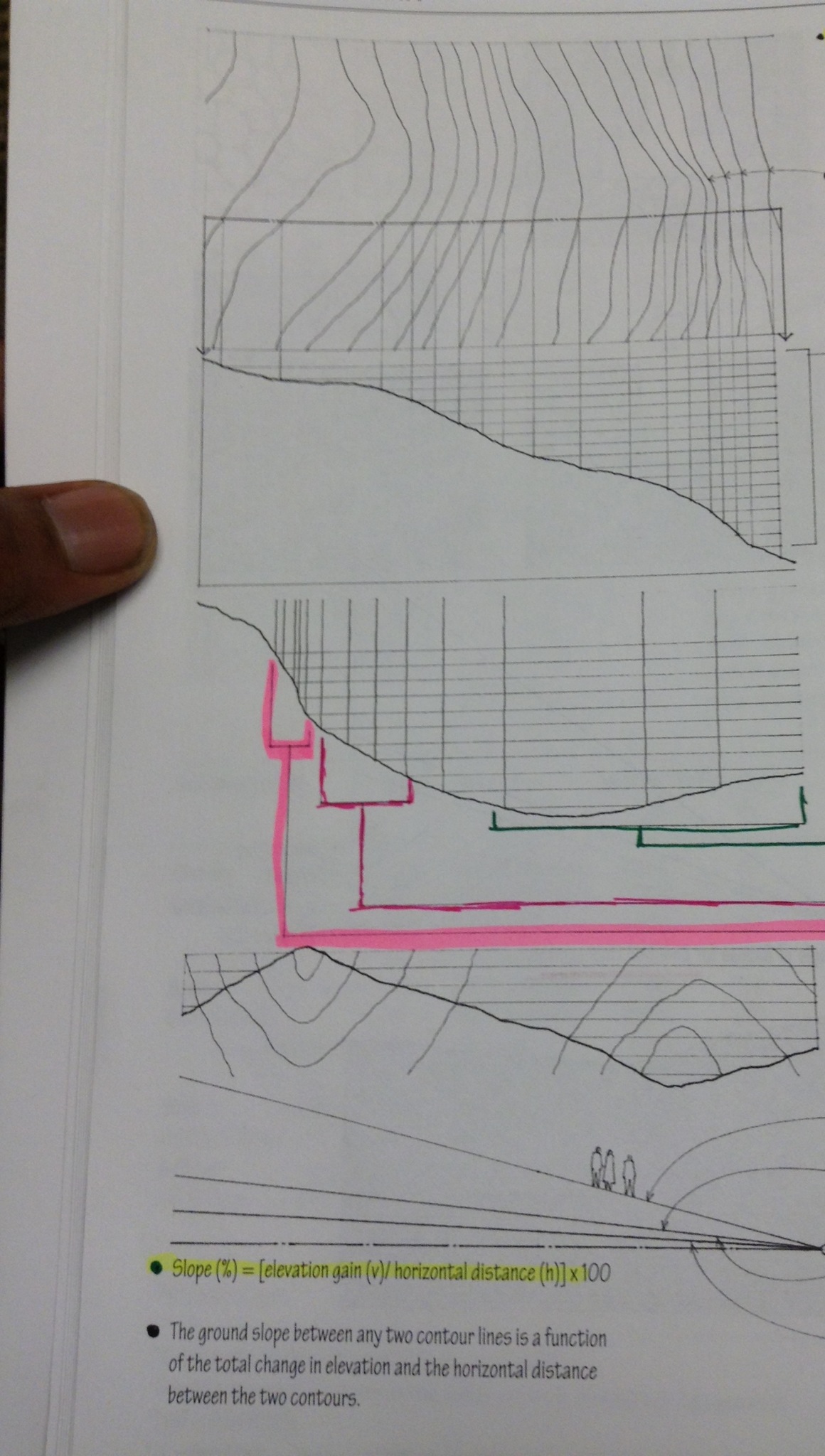
- Equally spaced contours denote a constant slope.
- Closely spaced contours disclose a relatively steep rise in elevation
- Contour lines represent a ridge when pointing toward lower elevations; they represent a valley when pointing toward higher elevations
-
SLOPES
- Ground slopes o
ver 25% are subject to erosion and are difficult to build on - Ground slopes over 10% are challenging to use for outdoor activities and are more expensive to build on
- Ground Slopes from 5% to 10% are suitable for informal outdoor activities and can be built on without too much difficulty
- Ground slopes up to 5% are usable fr most outdoor activities and relatively easy to build on
- Ground slopes o
TREES
Providing Shade
- The amount of solar radiation obstructed or filtered by a tree depends on its:
- Orientation to the sun
- Proximity to a building or outdoor space
- Shape, Spread, height
- Density of foliage and branch structure
- Trees Shading a building or outdoor space most effectively from the southeast during the morning and the southwest during the late afternoon when the sun has a low altitude and casts long shadows.
- South facing-facing overhangs provide more efficient shading during the midday period when the sun is high and casts short shadows
- Deciduous trees provide shade and glare protection during the summer and allow solar radiation to penetrate through their branch structures during the winter
- Evergreens provide shade throughout the year and help reduce snow glare during the winter
-
Serving as Windbreak

- Evergreens can form effective windbreaks and reduce heat loss from a building during the winter
- The foliage of plant materials reduces wind-blown dust
-
Defining Space
- Trees can shape outdoor spaces for activity and movement
-
Directing or Screening Views
- Trees can frame desirable views
- They can also screen undesirable views and provide privacy for outdoor spaces
-
Attenuating Sound
- A combination of deciduous and evergreen trees is most effective n intercepting and attenuating airborne sound, especially when combined with earth mounds
-
Improving Air Quality
- Trees trap particulate matter on their leaves, which is then washed to the ground during rainfall
- Leaves can also assimilate gaseous and other pollutants
- Photosynthesis process can metabolize fumes and other odors
-
Stabilizing Soil
- The root structures of trees aid in stabilizing soil, increasing the permeability of the soil to water and a, and preventing erosion

SOURCES:
“Building Construction Illustrated 4th edition” Francis D.K. Ching
Generally I do not read article on blogs, however I wish
to say that this write-up very forced me to take a look at and do so!
Your writing style has been surprised me. Thanks, quite nice
article.