-
Climate
- The determining factor of figuring out a climate or its average weather is understanding the suns angles (latitude) tropic, temperate, and artic zones. Because the atmosphere is almost completely invisible to solar energy from the sun the main heating of the air occurs at the earth’s surface. A global north-south flow of air is generated because the equator is heated more than the poles, the flow can alter because of the changes in seasons and the rotation of the earth. The rotation of the Earth deflects the north-south air currents by an effect known as the “Coriolis Force”. (In physics, the Coriolis Effect is a deflection of moving objects when they are viewed in a rotating reference frame. In a reference frame with clockwise rotation, the deflection is to the left of the motion of the object; in one with counter-clockwise rotation, the deflection is to the right.) Another factor of climate and the wind is the uneven distribution of landmasses on the globe; because of its higher heat capacity water does not heat up or cool down as fast as the land. Mountain ranges not only block advert winds but also have a major effect on the moisture content of the air. [For example over the Pacific Ocean solar radiation evaporates water and the air becomes more humid, the westerly winds blow this moist air overland, where it is forced up over the north-south mountain ranges. As it rises it cools down at a rate of 3.6°F for every 1000ft (300m) when the temperature drops, the relative humidity (RD) increases until it reaches 100 %. Any additional cooling will cause the moisture to condense in the form of clouds, rain, or snow. Along the mountain side because during the day the mountain surface heats up faster than the free air around it the warm air direction moves along the slopes during the days and down during the night because the mountain surface cools by radiation more quickly than the free air.
-
Micro climate
- A micro climate is noticed when the local climate is not matching with the climate region. If buildings are to relate to their environment the factors that are responsible for making the micro climate deviate from the macro climate are:
- Elevation above the sea level, the steeper the slope of the land the faster the temperature will drop with an increase in elevation.
- Forms of land, South-facing slopes are warmer than north-facing because they receive much more solar radiation due to the solstices and angle of the Earth. During the winter cold the South-facing slopes are protected from the cold because the winter winds usually blow in from the north, West slopes are warmer than east slopes because the period of high solar radiation bodies of water have a significant effect on temperature that generate daily breezes.
- Soil types, for the soil the water, color and heat capacity plays a role when determining the micro climate a well. Evaporation from the soil cools the air above the ground. Light colored sand can reflect large amounts of sunlight but at the same time it increases the radiation load on people or the buildings because o their high heat capacity. Rocks absorb the heat during the day and are released at night.
- Vegetation, shading and transpiration plants can reduce the air temperature and ground temperatures and also increase humidity even if it is already too high. Evapotranspiration is the term used to describe evaporation from the soil and transpiration (the passage of gases through fine tubes because of differences in pressure or temperature.) from plants. The idea for the hotter climates is to have high canopy trees for protection from the sun and no low plants so that the breeze would not get blocked or lowered. Colder climates plants can reduce the cooling breeze effect from the wind,
- Man-made Structures, the construction done by man plays a more controllable climate role for a micro climate because the schematics that are planned (buildings, streets, parking lots) have different characteristics than what is natural. (size mass and color)
- Relative Humidity
- Evaporation of skin moisture that gets absorbed by the dry air causing rapid evaporation that will effectively cool the body. Low relative humidity levels causes the dry noses, mouths, eyes, and skin and increases in respiratory illnesses. High humidity reduces the evaporating cooling rate but also causes high rate of mildew growth.
- Mean Radiant temperature: the surface radiant fluctuations. (reach of temperature fluctuations)
- A micro climate is noticed when the local climate is not matching with the climate region. If buildings are to relate to their environment the factors that are responsible for making the micro climate deviate from the macro climate are:
Hours of Daylight per Day (15th day of each Month)
|
Month |
30°N |
40°N |
50°N |
| January | 10:25 | 9:39 | 8:33 |
| February | 11:09 | 10:43 | 10:07 |
| March | 11:58 | 11:55 | 11:51 |
| April | 12:53 | 13:15 | 13:45 |
| May | 13:39 | 14:23 | 15:24 |
| June | 14:04 | 15:00 | 16:21 |
| July | 13:54 | 14:45 | 12:57 |
| August | 13:14 | 13:46 | 14:30 |
| September | 12:22 | 12:28 | 12:39 |
| October | 11:28 | 12:28 | 12:39 |
| November | 10:39 | 9:59 | 9:04 |
| December | 10:14 | 9:21 | 8:06 |
Climatic Region Information:
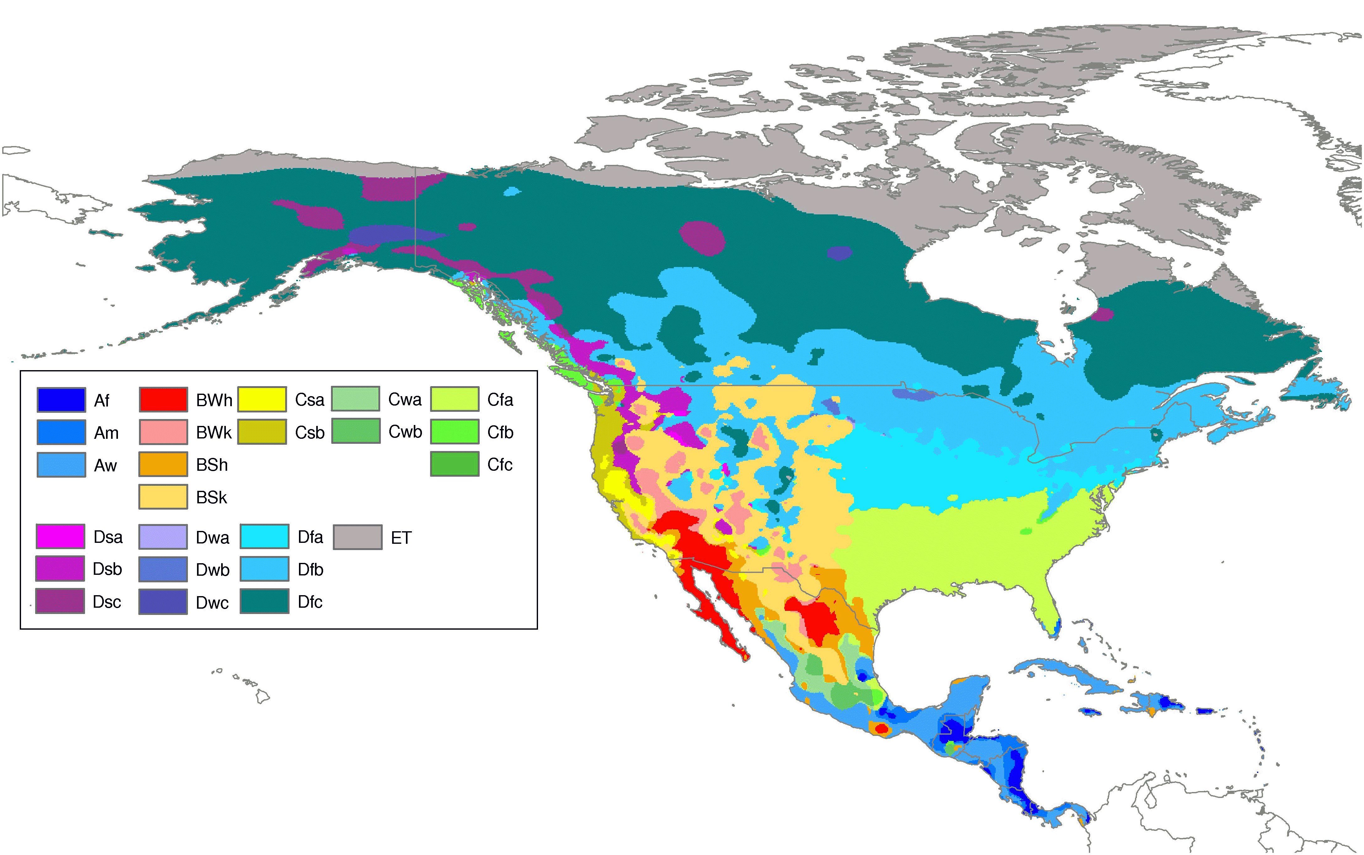
Köppen Climate Classification System
The Köppen Climate Classification System is the most widely used for classifying the world’s climates. Most classification systems used today are based on the one introduced in 1900 by the Russian-German climatologist Wladimir Köppen. Köppen divided the Earth’s surface into climatic regions that generally coincided with world patterns of vegetation and soils.
-
The Köppen system recognizes five major climate types based on the annual and monthly averages of temperature and precipitation. Each type is designated by a capital letter.
- A – Moist Tropical Climates are known for their high temperatures year round and for their large amount of year round rain.
- B – Dry Climates are characterized by little rain and a huge daily temperature range. Two subgroups, S– semiarid or steppe, and W – arid or desert, are used with the B climates.
- C – In humid Middle Latitude Climates land/water differences play a large part. These climates have warm, dry summers and cool, wet winters.
- D – Continental Climates can be found in the interior regions of large land masses. Total precipitation is not very high and seasonal temperatures vary widely.
- E – Cold Climates describe this climate type perfectly. These climates are part of areas where permanent ice and tundra are always present. Only about four months of the year have above freezing temperatures.
-
Further subgroups are designated by a second lower case letter which distinguishes specific seasonal characteristics of temperature and precipitation.
- f – Moist with adequate precipitation in all months and no dry season. This letter usually accompanies the A, C, and D climates.
- m – Rainforest climate in spite of short, dry season in monsoon type cycle. This letter only applies to A climates.
- s – There is a dry season in the summer of the respective hemisphere (high-sun season).
- w – There is a dry season in the winter of the respective hemisphere (low-sun season).
-
To further denote variations in climate, a third letter was added to the code.
- a – Hot summers where the warmest month is over 22°C (72°F). These can be found in C and D climates.
- b – Warm summer with the warmest month below 22°C (72°F). These can also be found in C and D climates.
- c – Cool, short summers with less than four months over 10°C (50°F) in the C and D climates.
- d – Very cold winters with the coldest month below -38°C (-36°F) in the D climate only.
- h – Dry-hot with a mean annual temperature over 18°C (64°F) in B climates only.
- k – Dry-cold with a mean annual temperature less than 18°C (64°F) in B climates only.
-
Resources:
- https://courses.cit.cornell.edu/arch261/Notes.html
- “Heating Cooling and Lighting Sustainable Design methods fir Architecture” Norbert Lechner
- “Building Construction Illustrated 4th Edition” Francis D.K. Ching
- http://www.blueplanetbiomes.org/climate.htm